
Vector data for the border regions and districts located in Turkey. 2023.
Please ask for prices:
info@adresharita.com
adresharita@gmail.com
Telephone: 0090546 848 38 83 (or Whatsapp)
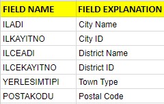
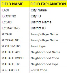
It covers all villages and districts registered to UAVT. There are 32,006 neighborhoods and 18,377 villages in our country. The number of cemeteries and districts connected to these is 23.955 and is not defined by any administrative borders.
It is in the WGS-84 coordinate system. SRID = 4326. (En çok kullanılan projeksiyonlar için tıklayınız)
Data is available in Esri ShapeFiles, SQL, Access (mdb), kml-kmz, GeoDatabase (gdb), Json formats.
It will be delivered by e-mail within 1 day.
All Turkey, Canton province, can be obtained from county districts. To visualize the data you receive from a map tool, you can obtain it from AddressHarita if you do not have neighborhood data.
It is updated twice a year. The updates are 20% of the data price.
Turkey’s blog where we post the details about the administrative structure.